Dashes and symbols
Dashed CAD exports chain into one run, and symbols drawn over the line are bridged, so a run isn't broken into pieces.
Tracing a storm run one bend at a time, then re-typing the footage into Excel for trench, bedding and truck loads, is two takeoffs for one pipe. CivilTrace reads the line work and callouts already in a vector PDF plan set, so one click measures the run and the quantities behind it are worked out with your own constants.
Windows 10 and 11, 64-bit. Storm, sanitary, water, fire, irrigation, reclaimed, gas, electric and telecom.
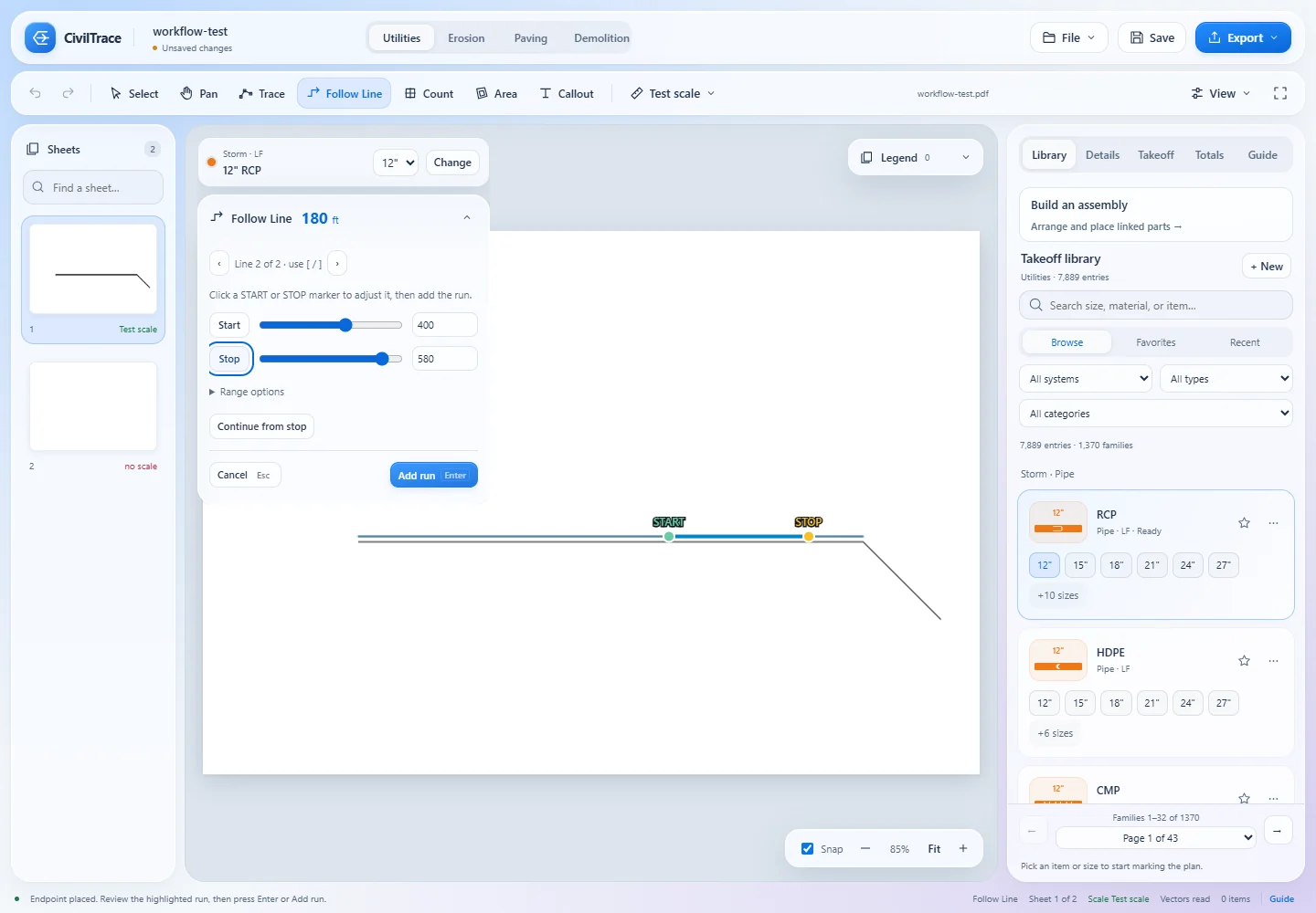
A storm run, start to finish
The same loop for every run on the set, with a keyboard shortcut for each step.
Drag the PDF in. Sheet numbers, titles and scale notes are read from the title block. Calibrate from two points or pick a preset like 1" = 40', and apply it to every sheet.
Search the library the way you'd say it: 18" rcp, 8" pvc, 8x8x6 wye. The card at the top always shows what the next click will measure.
F Follow Line measures the drawn run in one click. Adjust the START and STOP markers, cycle to a nearby line, or continue from the stop at a junction.
T Read Callout fills in size, material, slope and system from the text beside the run. Enter rim and invert and depth and slope calculate as you type.
S Count dropped near SSMH-4 or FH picks its type from the label: manhole, hydrant, inlet. Attach fittings and structures to their pipe so production sheets group them once.
The Guide lists missing scales, missing sizes and unconnected fittings. Then one Export menu writes the workbook, production sheet, review PDF, CSV and DXF.
Follow Line
Utility plans are full of things that trip up a polyline: dashes, symbols on the line, matchlines and profiles. Follow Line handles them.
Dashed CAD exports chain into one run, and symbols drawn over the line are bridged, so a run isn't broken into pieces.
Runs stop at matchlines, and profile grids are ignored, so the pipe shown in profile isn't added to the plan quantities.
Find like this proposes every other line drawn in the same style, across all sheets, each with its own length, for you to accept.
Contractor math built in
The numbers you'd work out in Excel, done per run with your own constants. Change any of them per run, per system or for the whole project.
| Quantity | How CivilTrace gets it |
|---|---|
| Pipe LF | Follow Line or Trace, by system, material and size. |
| Fittings | Counted as run × run × branch (8x8x6 wye), linked to their pipe. Build a tee, valve and reducer assembly and place it in one step. |
| Structures | Smart counts typed from the label, with box excavation for each structure. |
| Depth and slope | From rim and invert callouts or your entries, calculated as you type. |
| Trench and embedment | Trench width by pipe size, bedding and pipe-zone material, with an embedment roll-up by system in the workbook. |
| Haul | Tons, waste, swell and truck loads. |
| Wet sections | Flagged against your water table, with dewatering and wet bedding created over the wet length. |
| Production | A production workbook with LF/day and crew-hour inputs and live formulas for days, hours, tons and loads. |
Exports
Every export comes from the same calculator, so Totals, the legend, the workbook, the CSV and the PDFs match.
A summary by scope with an embedment roll-up by system, plus a production workbook with a sheet per system and blue input cells.
Original sheets with selectable, unflattened markups, quantity comments and a layer per scope. How CivilTrace compares with Bluebeam.
A bid-item list for estimating systems, and takeoff geometry in feet with one layer per system for AutoCAD and Civil 3D.
Trenches, depth cutaways and crossings in a single HTML file anyone can open offline. Shapes are schematic, so use it as a scope check.
FAQ
Storm, sanitary, water, fire, irrigation, reclaimed, gas, electric and telecom. Each system has its own colour, line weight, dash pattern and tag, so a water main, a fire main and a sewer stay distinct on the plan, in the legend and in every export.
No. Profile grids are ignored and runs stop at matchlines, so plan quantities aren't doubled. Dashed CAD exports chain into one run, and symbols drawn over the line are bridged.
No. Depths come from rim and invert callouts or from what you enter, and CivilTrace calculates depth and slope as you type.
Follow Line, Find like this and edge-following need the vector line work in a PDF exported from CAD. Scanned or rasterized sheets still open, and you can measure them with manual Trace, without snapping.
Yes. Trench width by pipe size, bedding and pipe-zone material, tons per CY, waste, swell, truck size, water table depth and production rates are all editable defaults, per run, per system or project-wide.
The Export menu writes an Excel workbook, a production workbook with live formulas, a CSV bid-item list, a Bluebeam review PDF and DXF from the same calculator. There's no direct HCSS, B2W or Procore connector; the CSV bid-item list is the bridge.
Yes. Email kebraearthwork@gmail.com for a 7-day trial key, download the installer, and open a storm or sanitary set you're bidding now.

Try it on your next utility bid
Windows 10 and 11, 64-bit. One-click installer, about 160 MB. Free for 7 days with a trial key (measure and view; exports unlock with a plan), then $79 a month, $780 a year or $4,000 once.
The download starts right away. File: CivilTrace-Setup-x64.exe. Every feature, scope and export is on the home page.